
An approach to the market and technological development of GPS, its combination with GPRS communications for monitoring vehicle consumption and safety, vector cartographic needs and the strong impact of these on PNDs.
by Iván Darío Quintero
The story of where am I? and where am I going? it is quite transcendental and dates back thousands of years, but for the purposes of this article, I invite you to think only of a location and a space on the face of the earth.
For millennia compasses and stars have guided the paths of our humanity, both have served as a guide and have allowed us to get an idea of where we are and where we are going, but human beings have never served us to have an idea of something, we have always wanted to know everything for sure.
The history of GPS, although it seems impossible, can date back to 4,000 years a.c, since it is known that by that time in Mesopotamia they had already established some dispositions of the stars in the sky that determined shapes, which among other things served to guide travelers. Also by 2,500 B.c the Chinese claim that they had already invented the compass to determine the north. From then on, navigation charts and country maps became a key reference for any traveler.
Through these tools it was possible to know where you were or where you were going, however to know where something is all the time and how the road to a certain place is, are things that are just beginning and seen as possible in recent history.
In the twentieth century in the early 60s, during the Cold War, when the United States and the USSR felt the need to know where their fleets, their vehicles or their armaments were, they began to develop a monitoring system based on satellite systems that would give them this information. A few years later, each country already had its satellites in low orbit, the result was an intermittent signal and they did not get the expected results.
Almost a decade later after an injection of 12 billion dollars the Ministry of Defense of the United States began to develop the Navstar GPS project, Global Position System, leaving the USSR behind; the objective of the great project was to launch 24 satellites to medium orbit (1100 Km) to be able to constantly monitor the fleets, read submarines tanks, airplanes etc. But it was only until the end of 1983 that the initial operational phase of gps was declared.
Between 1978 and 1985, eleven experimental NAVSTAR satellites were launched; subsequently they sent other generations of satellites to complete the NAVSTAR GPS constellation that would have 24 satellites in total, the system was declared with initial operational capacity in December 1993 and full in April 1995.
The final constellation of GPS satellites was established in 21 main units plus three spare assets, these are orbiting the Earth spread over six orbits, so that there are four satellites per orbit, so from any point on earth five satellites are in sight. Thanks to this, today any device equipped with a GPS receiver interprets these satellite transmissions and gives the exact coordinates of the place where it is located, the receiver computes its own distance from a minimum of three satellites using a simple mathematical formula derived from a triangulation and is able to calculate its own length, latitude, speed and even altitude.
Initially, the project was only available for military uses, but in 1980 former US President Ronald Reagan released the GPS system for civilian use, also allowing it to be free; at that time the information offered by the constellation was not the most accurate, although the application of military use was a little more accurate; with the passage of time and with the entry into operation of a new block of satellites called Block IIR, the system became more accurate, the correct global positioning information is allowed for civilian uses since 1999, although there is still talk of a margin of error of between five and 15 meters.
GPS for everyone
Since then, companies have been born that have offered all kinds of equipment, software and services related to GPS: devices for monitoring transport fleets, the popular PND (Personal Navigation Devices), third-party monitoring services, cartography, synchronization systems, military and space applications among others.
The demand for these products and services has not been long in coming, the wide offer directly impacts niches such as security and gadgets, the first most requested by car manufacturers, insurers and owners of cargo and passenger transport fleets, and the second much more desired by individuals.
To date, in the niche of vehicle safety, the implementation of GPS for vehicle recovery is becoming practically the norm, this because it helps manufacturers and owners to have control over their properties, this system is required by insurers in Uruguay, Paraguay and Argentina for cars worth more than $30,000; in the same way and ratifying that this technology is here to stay, in the federal district of Mexico from this year all 0 km cars must come with this equipment installed.
And is that the market that has won this technology would only be compared to the Internet, according to the University of Washington, the economic impact of GPS technology, only in areas of security, could reach 50,000 million dollars worldwide by 2010. Currently, the figure is around 6,000 million, with Europe in the lead, with 60%, followed by the United States.
In Latin America the implementation of these technologies has been a bit slow but growing by leaps and bounds, according to Eduardo Nina, commercial manager of Logicsat, a company that provides the monitoring service in several Latin American countries, in Uruguay and Paraguay the growth of these technologies is significant; of Brazil believes that the issue of tracking in the field of truck fleet is quite developed, in Argentina thinks that the situation is similar, especially because of the issue of safety, in any case Eduardo considers that the boom of this technology has not yet occurred in this area.
In Colombia, according to Teleguardia operation manager Jaime Guzmán, this technology is just beginning to explode strongly in the country. However, in the case of Mexico, development is much greater compared to the rest of Latin America, not only because it is one of the countries with the highest growth and demand for these services due to its own characteristics and the enormous nature of the country. but also this demand obeys guidelines and regulations imposed by the Government, as clarified by Soledad Mora of Hunterpro, a manufacturer of hardware and software for monitoring.
However, the business has gone beyond simple global positioning, which more than vehicles is able to locate anything on earth that has a device capable of interpreting the signals of satellites, which could even be used to find your pet.
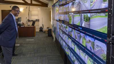
Companies around the world provide the service of monitoring or tracking of vehicles and transport fleets, offering in real time information about the location of these, the speed and proximity to a certain place; this information is sent to the interested party to his cell phone and can also be supervised by him from a web platform, a very useful service for cargo transport companies, taxis, ambulance buses etc.
Transport fleet monitoring
According to Eduardo Nina "in each car a device is installed that, in addition to a GPS, has a data transmission modem via GPRS and a processor; what the modem does is take the information from the processor and send it via GPRS to the call center." In other words, a GPS decoder is installed in the car, which takes the signals from the satellite and determines the position, this information is taken by the processor, which converts it to a data transmission language and sends it through the modem via GPRS to the central.
Also, as Soledad Mora told us, the information can be sent directly to the interested party's cell phone. The question here was why should we use another technology? Are GPS satellites not able to allow this communication? Thanks to Soledad Mora, we know that satellites are also able to offer the communication service, but it turns out that it is quite expensive.
In the same way he explained: "graphically there are three major divisions in this issue of vehicle monitoring, the three divisions come by the way of transmitting the data, then, in the first division you have equipment that uses GPS to obtain the satellite data, the location, but these send the information to the central by means of RF, radio frequency; disadvantages: the coverage is minimal and does not ensure the monitoring of the vehicle." "Second, systems with GPS but that transmit by GSM / GPRS, which are the most used in the world, since GSM technology has a lot of coverage and the costs per communication are lower and the time of arrival of the data is three seconds. "Third you have the pure satellites, they use GPS for everything, to obtain the data and to communicate with the central; disadvantages: the price is very expensive, not only the equipment but the contracting of the satellite communication space, in addition the time of arrival of the data is much longer than the GSM, from five to 30 minutes, I know they are used for trucks that transport valuable loads through jungle areas, sea and air."
Soledad also made clear about the most used communication technology in the world to perform monitoring, GSM / GPRS: "within the range of GSM services we find that you can use the sending of information by SMS text messages or through data packets that travel over the GPRS internet. The advantage of GPRS is that being lighter packets allow a more frequent use of them without saturating the network, then you can receive the GPS information every 30 seconds, a minute, etc., according to the needs of the client. " "On the other hand, the SMS has a much slower data management in the telephone exchange and with the frequent sending of these messages, the network can be delayed in responding, it is used more than anything when the client does not need to know at all times the status of the vehicle, but simply when you require them occasionally, and to receive any emergency message or out of the ordinary, then for costs it is convenient for SMS communication to that client, instead in the first case the best thing is GPRS, for its benefits for real on-line communication with the monitoring center ".
Technology for every sector
In such a way that the companies dedicated to monitoring have found a great ally in the GPRS for the transmission of data, to such an extent that thanks to this communication system the monitoring companies have expanded the service, in addition to reporting the position offered by the GPS, that allows to know where the vehicles are in a city or in an area of operation thanks to satellites and subsequent calculations with software to locate them in cartographies, the companies are also installing sensors that report from the consumption of gasoline to the opening of doors, going through temperature controls, cameras, microphones, panic alarms, passenger counters, in short... almost anything unimaginable.
In addition to the fact that the GPRS communication system allows sending messages directly to the cell phone of the end users, companies such as Teleguardia and Logicsat have mounted web platforms, where the customer with a username and password can access historical data, verify the position of their vehicles, turn on a siren, activate the passage of fuel, see what happens in the cabin etc.
Digital, satellite and vector maps
But for the issue of positioning to be a success, it became necessary to possess, in addition to the information provided by the constellation of satellites, a large number of maps of cities, regions and roads on which the coordinates delivered by the GPS could be located, which are nothing more than numbers indicating latitude, length and degrees, for this reason monitoring companies must have software applications that quickly locate these coordinates on digital, satellite or vector maps.
According to Soledad Mora, this issue continues to be a great challenge in our region, and it is perhaps in the part that we are most behind the countries that lead in these matters; such is the case throughout Europe, the United States and Israel. "Well, first of all the cartography for vehicle systems must be vector maps calibrated for use with GPS, the detail is that of these maps there are several formats and not any format serves for vehicle monitoring systems; these maps are very expensive and you also have to be constantly updating them."
"In addition, the difference between a vector map with a rapster map, which is what scanned images of very good definition maps are called, is that vectors have many layers, one of them is a database with the names of the streets and roads of a certain city, for this reason, certain addresses can be inserted into the software and the databases refer to the places indicated on the map, to show for example the vehicle closest to that address," said Mora.
He also explained that "another increasingly expanded alternative is the use of satellite imagery from Goolge Earth; through web platforms users can access from any PC in the world and have visualization of their vehicles and observe them on Google maps, the good thing about these maps is that they are very beautiful and very good definition ".
However, according to systems engineer Byron Herrera the basic difference between vector maps and digital or satellite maps is the weight of the file, because a digital image will weigh much more than a map drawn through vectors, for whose realization programs such as Corel or Freehand are used. this overweight will undoubtedly be reflected in the transmission of data and in the speed of applications.
Vector cartographic developments have their main developments in countries such as Canada, the United States and Europe, but there it has not been monitoring by third parties that has encouraged their development.
The devices called PDA (Personal Navigation Devices) are gaining the approval of thousands of users thanks to vector maps that allow to know in real time the conditions of the road, the shortest way to reach a certain place, among other large amounts of information that it is possible to obtain to users through software applications that are obtained to install on these computers. These systems also offer three-dimensional images of historical monuments, even indicating the location of speed detectors on the roads.
In conclusion, in our region GPS monitoring and communication with GPRS moves strongly, motivated mainly by security, however the market for gadgets such as PND Autonomous Navigators and PDAs is still incipient and has not impacted the Latin American market much.
As already mentioned in Europe and other regions of the world there is a wide consumption of these devices, just to mention something, according to calculations by the consultants Tele Atlas and Canalys, in Europe approximately 11 million units of these equipment were sold in 2006 and 17 million in 2007, for this year they expect 22 million units to be sold.
The compass and the stars were for thousands of years the guide to determine the north or to know where we were, today the PND are our compasses, but they do not only indicate the north but also the best way to it, and satellites are our stars, but these stars do not tell us where we could be, but where we are.


Leave your comment